FASCINATING PLACES NEAR THE LINES
I find all the revelations on the lines fascinating but these are some that are extra special.When I say these spots are near the lines, I mean near...just a couple of fields away.
If you look at the photo above, the place where I put my dial is in the field between the tomb and the passage way. This is where the angles from the two outer walls of the tomb meet.
If you look at the photo above, the place where I put my dial is in the field between the tomb and the passage way. This is where the angles from the two outer walls of the tomb meet.
CARROWKEEL
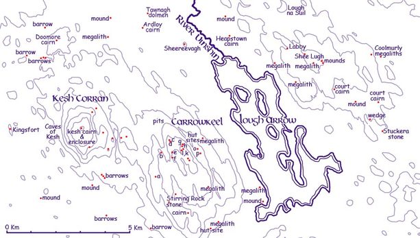
If I place my dial at Labbacallee and it reads latitude 52.17419695, and I move the arm of the dial directly north to the Carrowkeel Complex Cemetery Tomb near Lough Arrow, the angle will measure -0.01848841.The acuracy of this measurement, given that it is 285km approx by car, and taking in the curvature of the earth is extraordinary. The radiating line then continues between the two islands of Annaghgowk and Inishmore in Lough Arrow less than one km to the east of Heapstown Cairn which is Ireland's fourth largest neolithic monument. The Heapstown Cairn was where the Battle of Moytura was waged against the Formorians .
If I place my dial at Labbacallee and it reads latitude 52.17419695, and I move the arm of the dial directly north to the Carrowkeel Complex Cemetery Tomb near Lough Arrow, the angle will measure -0.01848841.The acuracy of this measurement, given that it is 285km approx by car, and taking in the curvature of the earth is extraordinary. The radiating line then continues between the two islands of Annaghgowk and Inishmore in Lough Arrow less than one km to the east of Heapstown Cairn which is Ireland's fourth largest neolithic monument. The Heapstown Cairn was where the Battle of Moytura was waged against the Formorians .
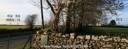
When I place my dial on Carrowkeel Complex and come directly south, I will end up eight trees up from Labbacallee.( about 20 metres) You can see three of these trees in the photo to the left.( I live with a cynical bunch...so this needs to be explained!)
 http://www.carrowkeel.com/
http://www.megalithicireland.com
Carrowkeel Complex overlooking Lough Arrow
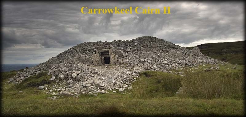
Carrowkeel is a beautifully situated neolithic hilltop passage tomb cemetery consisting of 14 passage cairns identified with letters. The passage cairns are spread across a number of hills that form part of the Bricklieve Mountain range (the Irish name Breac sliabh means speckled mountain).
Situated: From Castlebaldwin on the N4 head west into the Bricklieve mountains, following the signs for Carrowkeel Passage Tombs. Turn left at the sign for the donkey sanctuary, then first right. Go through the gate and park at the top of the hill. A 10 minute walk along the track brings you to the old car park. Head right up to the cairns.
http://en.wikipedia.org/wiki/Carrowkeel_Megalithic_Cemetery
Carrowkeel Complex overlooking Lough Arrow
Carrowkeel is a beautifully situated neolithic hilltop passage tomb cemetery consisting of 14 passage cairns identified with letters. The passage cairns are spread across a number of hills that form part of the Bricklieve Mountain range (the Irish name Breac sliabh means speckled mountain).
Situated: From Castlebaldwin on the N4 head west into the Bricklieve mountains, following the signs for Carrowkeel Passage Tombs. Turn left at the sign for the donkey sanctuary, then first right. Go through the gate and park at the top of the hill. A 10 minute walk along the track brings you to the old car park. Head right up to the cairns.
http://en.wikipedia.org/wiki/Carrowkeel_Megalithic_Cemetery
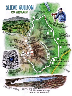
SLIEVE GULLION
(on the 30 degree line)
http://mournecooleygullion.com/attractions/gullion/slieve-gullion-mountain-driveThe 13km scenic Slieve Gullion Mountain Drive in Co Armagh takes the visitor to a marked trail leading to the Neolithic passage tomb on the south summit of Slieve Gullion and continuing on to Cailleach Beara’s Lough and Bronze Age cairn on the north side of the mountain.
http://www.independent.ie/lifestyle/travel/inside-ireland/walk-of-the-week-slieve-gullion-co-armagh-26543944.htmlHere is the house of the Cailleach Beara, the unspeakably wicked witch who turned mighty Fionn Mac Cumhaill into the feeblest of old men in the time it took him to dive into the Lake of Sorrows to retrieve her golden ring. Of course, the fact she'd disguised herself as a beautiful, shapely young maiden in distress had nothing to do with Fionn's recklessness.
 Tlachtga where the Great Fire Festival at Samhain was celebrated.
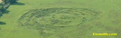
THE HILL OF WARDhttp://www.knowth.com/hill-of-ward.htm
( on the 30.4288 degree line)
Tlachtga (Hill of Ward) near Athboy, Co Meath is 12 miles from the Hill of Tara. The earthworks which are about 150 metres in diameter are most impressive from the air. Tlachtga dates from approximately 200 AD and was the location of the Great Fire Festival begun on the eve of Samhain (eve of the 1st November).
The festival probably lasted for least several days and centred on the god Lugh. The site takes its name from Tlachtga the daughter of the Druid Mug Ruith who died there giving birth to triplets. Tlachtga is clearly visible from Tara and the fire lit on the eve of Samhain was a prelude to the Samhain Festival at Tara.
 http://www.rathcroghantours.com/
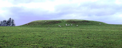
RATH CROGHAN
( on degree 0.4876)
http://www.voicesfromthedawn.com/rathcroghan/
Although the mounds likely date from the Bronze Age, thousands of years earlier than the Iron Age fiefdoms of Ireland, tradition considers this the inauguration site of the Kings of Connacht.5 Crúachan was most famously the home of Ailill, King of Connacht due to his marriage to the quasi-divine Queen Medb, the cunning antagonist of the Ulster hero Cúchulainn in the Táin (Táin Bó Cúailnge, The Cattle Raid of Cooley).
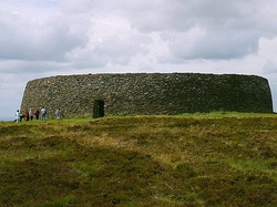
GRIANAN AILEACH
http://en.wikipedia.org/wiki/Grianan_of_Aileach
The Grianan of Aileach (Irish: Grianán Ailigh, sometimes anglicised Greenan Ely) is a group of historic structures atop a 244 metres (801 ft) hill in County Donegal, Ireland. The main structure is a stone ringfort, thought to have been built by the Uí Néill in the sixth or seventh century CE;[1] although there is evidence that the site had been in use before the fort was built. It has been identified as the seat of the Kingdom of Aileach and one of the royal sites of Gaelic Ireland.
The royal sites of Ireland served as the seats for the Gaelic kings of Ireland. Historical sources associate these sites with various medieval Irish kingdoms while archaeological investigations show that many royal sites were culturally significant thousands of years before recorded history. Ancient monuments, such as Neolithic burial mounds, standing stones, and cairns date back thousands of years and indicate the recurring—or even continuous—significance of these sites through millennia
