DIAGRAM OF THE TOMB
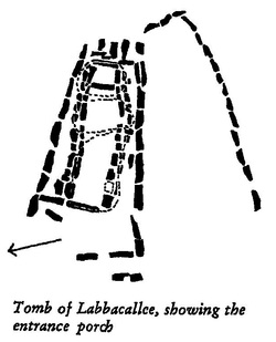
The diagram of the tomb is interesting because it clarifies the position of the stones.
Originally there would have been two spurs of stones on either side of the tomb, but only one spur remains, The large stones which make up the tomb would have been covered with small stones, and earth and grass would gradually have grown over the entire tomb. These little stones are now gone, probably used in the construction of the road, and only the larger, heavier stones remain. Some of these have fallen down or been knocked down over the years.
http://www.megalithic.co.u
Brian Clancy in his book Ireland in the time of the Rings says that Labbacallee is "exactly at the halfway or cross-way point between the stone at Ballycrovane and Newgrange. It is also 112 km from Bannow Bay. Cush Fort was also built at this time using the RR1 from Ballycrovane"Stone. (RRI stands for Royal Ring 1 or 127 kms in distance from the Ballycrovane Stone Stone)
The Ballycrovane Ogham Stone (Béal A’Chorraigh Bháin) stands an impressive 17 feet (approx. 5.2 metres) The Ogham writing is very worn and appears to have been added several years after the stone was erected. Some of the carving is awkward and slanting, suggesting the markings were carved in it while the stone was upright. The standing stone (menhir) was carved with the words MAQI-DECCEDDAS AVI TURANIAS. Various sources have translated it as ‘Of the son of Deich descendant of Torainn‘.
Newgrange was constructed over 5,000 years ago (about 3,200 B.C.), making it older than Stonehenge in England and the Great Pyramid of Giza in Egypt. Newgrange was built during the Neolithic or New Stone Age by a farming community that prospered on the rich lands of the Boyne Valley. Knowth and Dowth are similar mounds that together with Newgrange have been designated a World Heritage Site by UNESCO.http://www.newgrange.com/
The Norman conquest of Ireland began in Bannow Bay in 1169, when three ships commanded by Robert Fitz-Stephen arrived at the behest of Diarmait MacMurrough to support his claim to the Kingdom of Leinster. Another group of Normans under Raymond le Gros landed the following year on the far side of Bannow Bay, on the Hook Peninsula at Baginbun, which was then called Irish: Dún Domhnaillhttp://en.wikipedia.org/ (Interesting to note that Raymond le Gros was meant to have built Glanworth Castle)
The townland of Cush is located on the western slopes of Slievereagh, about 700 to 800 feet high, and two miles north of Kilfinane. Cush contains an extensive complex of ancient fields and enclosures, and was excavated in 1932-1934. These excavations revealed that the site was continuously occupied by an agricultural community from around 1000 BC to 400 AD.
To the south, six ring forts were joined together with a large rectangular enclosure located to the west. Seventy rotary querns, glass beads, a Bronze Age urn, an abundance of iron slag and several burials were found. One fort was apparently set aside as a burial ground, while other cremated burials in decorated urns were discovered under Bronze Age mounds. A field system, marked out by earth banks and ditches of the early Iron Age or early Christian Era, surrounds the site.Coordinates: 52°22’52″N 8°26’34″Whttp://visitballyhoura.com/
